


.JPG "Exquisite Properties")


Sandton, Gauteng, South Africa
Agent: Cliff Jacobs - Managing Principal Estate Agent & CEO (Nat.Dpl.Hotel Man (UJ). M.P.R.E.)
Agent Cellphone: +27 (0) 84 413 1071 / +27 (0) 61 716 6951
Agent Office Number: +27 (0) 84 413 1071
Agent Email Address: cliff@exquisitehotelconsultants.com
Type: Hotel
Bedrooms: 950
Bathrooms: 950
Showers: 950
Parking: 1000
Yield: Not Disclosed
TGCSA Rating:

Sandton
Sandton is a financial centre of Johannesburg, South Africa and forms part of the City of Johannesburg Metropolitan Municipality. The name of the city came from the combination of two of its suburbs, Sandown and Bryanston. In 1969, Sandton was promulgated as a municipality in its own right, but lost its status as an independent city after the re-organisation of South African local governments after Apartheid ended.
History
Early settlers
Archaeological findings suggest the area, which Sandton comprises today, had originally been occupied by various indigenous groups, before European settlement, most notably the Tswana and, to a lesser extent, Sotho people. The remains of an Iron Age smelter was discovered in Lone Hill, a suburb of northern Sandton. One of the first Voortrekker parties to settle in the area were the Esterhuysen family on the farm Zandfontein (Afrikaans and Dutch for Sandy Spring or Sand Fountain). A monument to commemorate them may be found just off Adrienne Street in Sandown where the family cemetery is located. Zandfontein, Driefontein (Afrikaans and Dutch for Three Springs/Fountains) and Rietfontein (Afrikaans and Dutch for Reed Spring or Fountain of Reeds) encumbered what was to become Sandton. The municipal coat of arms of Sandton pays homage to the three farms with three round fountain barrels on its chevron. In the late 19th-century the Wilhelmi family of Hannover, Germany acquired the farm Driefontein No. 3 while Rietfontein was owned by the Ehler family. The original Driefontein homestead, now within the confines of the Field & Study Centre, was looted during the Anglo-Boer War. The ruins are visible on the northern bank of the Klein Jukskei River. The Wilhemi family, upon return from Germany built the 'new' 1906 Driefontein Farmhouse on what is present-day Fifteenth Street, Parkmore cum Riverclub. The farmhouse served as the icon and headquarters for the now defunct Sandton Historical Foundation and is listed as a City of Johannesburg Owned Heritage Site.
1960s and 1970s
Sandton was established as a separate municipality in 1969 by the office of the Administrator of the Transvaal. It had formerly not formed part of Johannesburg but was managed, in part by the 'parent city' and Pretoria through the North Eastern Peri-Urban Land administration. Initially it was very much a residential area consisting mostly of small holdings with a rural "horsey" lifestyle attracting many of the upper-middle classes and Johannesburg elites. It was subsequently dubbed the "mink and manure" belt. The Rivonia Trial derives its name from the locality of Liliesleaf Farm within the Sandton suburb where many of the Black freedom fighters such as Nelson Mandela were captured by the South African state and subsequently tried for treason. Rivonia had previously been known as Edenburg and was changed to make itself distinct from Edenburg, Free State. It was named for the surname Riven. Sandton and its constituencies were traditionally relatively more liberal than surrounds. For example, the motion which never materialised by residents in favour for the inclusion of Alexandra, Gauteng then a demarcated black township in terms of the Group Areas Act, into Sandton's jurisdiction proved troublesome for the National Party government which had a strong constituency in the adjacent town of Randburg.
1980s and 1990s
The construction of Sandton City by Rapp & Maister (which was eventually taken over by the Liberty Group which still retains 75% of the complex) marked a significant change for the Sandton area. It created rapid commercialisation and industrialisation. Sandton came to symbolise the White Flight movement of Johannesburg and secured itself as Johannesburg's second Central Business District. After the demise of Apartheid, by 1996, Sandton initially formed part of the interim Eastern Metropolitan Substructure, and in 2000 came to be included, along with the former towns of Randburg and Roodepoort, as part of the newly demarcated City of Johannesburg Metropolitan Municipality thus losing its separate municipal government and town status. Despite this, Sandton is still unofficially earmarked as a distinct region of the city and operates as a macro-suburb.
Financial and business centre
Urban decay in downtown Johannesburg caused many corporate offices to move from the Johannesburg Central Business District to Sandton in the 1990s. It has become the new financial district of South Africa and Johannesburg's premier business centre. Much of the financial focus of Johannesburg has shifted from the Central Business District to Sandton. However, three of South Africa's four largest banks have kept their head offices in downtown Johannesburg, along with Transnet, the transport parastatal. The other bank, Nedbank, has its headquarters in Sandton. A considerable amount of the city's A-grade office space is to be found in Sandton. The JSE Securities Exchange, Johannesburg's stock exchange, relocated its offices to Sandton from the central business district in the late 1990s. Sandton's gain was the central business district's loss: it resulted from urban blight of the downtown Johannesburg area.
Sandton is home to the Sandton Convention Centre, one of the largest convention centres on the continent and primary site of the 2002 World Summit on Sustainable Development (also known as "Rio + 10"), which Johannesburg hosted. The convention centre also hosted the African National Congress' victory celebrations after the party was re-elected at the 2004 election.
Massmart has its head office in the Massmart House in Sandton. Ster-Kinekor has its head office in the Ster-Kinekor Office Park in Eastgate, Sandton. IBM's and Hewlett Packard's main Southern Africa and South Africa offices are in Sandhurst and Rivonia respectively. In 2013, petrochemical giant Sasol announced the development of their new headquarters in Wierda Valley, Sandton.
The Sandton Central commercial node, centred on the suburbs of Sandown and Sandhurst has some of the best and most expensive commercial properties and offices in South Africa. A number of new developments are underway including 6 Benmore (Capital Hill), Atrium on 5th, Alice Lane and Katherine and West which is situated directly opposite the Sandton Gautrain Station. One of the highest rated Green buildings in South Africa, the Upper Grayston Office Park, is located in Sandton.
Industrial areas situated in Sandton are Wynberg and Kramerville. Kramerville, once a run-down area, is now trendy and is the centre of the design and textiles industry in Sandton.
Tourism and retail hub
One of the main attractions in Sandton is Sandton City, which ranks among the largest shopping centres in Africa. The completion of this precinct by the Liberty Group was the catalyst for the subsequent development of this entire area. Together with Nelson Mandela Square, the centre, with some 144,000 m2 of shopping space, is one of the largest in the Southern Hemisphere (behind Chadstone Shopping Centre). Much of Johannesburg's business tourism is centred on Sandton, which has various 5-star hotels under the Southern Sun, Hilton, Radisson and Protea brands.
Liberty Group announced in 2008 that Sandton City will receive a R 1,77-billion upgrade. Nelson Mandela Square, formerly known as Sandton Square, was renamed in March 2004, after the unveiling of a 6-metre bronze statue of the former South African president. Liliesleaf Farm, where Nelson Mandela lived in the early 1960s and where many leading political activists were arrested in 1963 and tried as part of the now infamous Rivonia Trial, is just north of Nelson Mandela Square, close to the N1 Highway, off Rivonia Road. Discovery Holdings has, in 2018, completed a large new head office along with shopping mall in the area.
Old Mutual South Africa's head office, as of 2018, is being constructed. A 55-floor mixed use building, The Leonardo, become the tallest building in all of Africa at 234 metres (768 ft) following its topping out in 2018.
Concerns have been raised as to whether Sandton has the necessary road and water infrastructure to sustain the massive development that is characteristic of Johannesburg in the 21st century (since the demise of Apartheid and the Group Areas Act).
Sandton Central Management District
The central business area of Sandton is divided into three City Improvement Districts, which have a unified identity called the Sandton Central Management District, branded as Sandton Central. This district is responsible, using additional funds levied on its behalf by the municipality, for the provision of additional services. The Sandton Central Management district provides additional cleaning, law enforcement, beautification and planning services to the area it services.
Transport
Gautrain
Sandton houses the flagship station of the Gautrain rapid rail link. The station is located on the corner of West Street and Rivonia Road. The system has direct connections to OR Tambo International Airport and an inter-city commuter service from Pretoria through Rosebank to Johannesburg Park Station
Sandton's Gaubus network is very extensive, with direct routes to Fourways, Gallo Manor, Randburg and Rivonia. People can also connect busses and travel to many parts of Centurion, Marlbro, Parktown, Rosebank and Pretoria using the service
Roads
Sandton has an extensive road network that allows you to get around. The main freeway to get in to the city is the M1 freeway through the M60 offramp at Marlboro Drive, The M40 at Grayston Drive and the M30 at Corlett Drive. To get around, you can use the M9, M27, M71, M75 and M85.
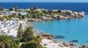
Cape Town
Cape Town (Afrikaans: Kaapstad; [ˈkɑːpstat], Xhosa: iKapa) is one of South Africa's three capital cities, serving as the seat of the Parliament of South Africa. It is the legislative capital of the country, the oldest city in the country, and the second largest (after Johannesburg). Colloquially named the Mother City, it is the largest city of the Western Cape province, and is managed by the City of Cape Town metropolitan municipality. The other two capitals are Pretoria, the executive capital, located in Gauteng, where the Presidency is based, and Bloemfontein, the judicial capital in the Free State, where the Supreme Court of Appeal is located.
Cape Town is ranked as a Beta world city by the Globalization and World Cities Research Network. The city is known for its harbour, for its natural setting in the Cape Floristic Region, and for landmarks such as Table Mountain and Cape Point. Cape Town is home to 66% of the Western Cape's population. In 2014, Cape Town was named the best place in the world to visit by both The New York Times and The Daily Telegraph.
Located on the shore of Table Bay, the City Bowl area of Cape Town, is the oldest urban area in the Western Cape, with a significant cultural heritage. It was founded by the Dutch East India Company (VOC) as a supply station for Dutch ships sailing to East Africa, India, and the Far East. Jan van Riebeeck's arrival on 6 April 1652 established the VOC Cape Colony, the first permanent European settlement in South Africa. Cape Town outgrew its original purpose as the first European outpost at the Castle of Good Hope, becoming the economic and cultural hub of the Cape Colony. Until the Witwatersrand Gold Rush and the development of Johannesburg, Cape Town was the largest city in southern Africa.
The city has a long coastline on the Atlantic Ocean, which includes False Bay, and extends to the Hottentots Holland mountains in the East. The Table Mountain National Park is within the city boundaries and there are several other nature reserves and marine protected areas within and adjacent to the city, protecting the diverse terrestrial and marine natural environment.
Geography and the natural environment
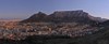
Cape Town is located at latitude 33.55° S (approximately the same as Sydney and Buenos Aires and equivalent to Casablanca and Los Angeles in the northern hemisphere) and longitude 18.25° E. Table Mountain, with its near vertical cliffs and flat-topped summit over 1,000 m (3,300 ft) high, and with Devil's Peak and Lion's Head on either side, together form a dramatic mountainous backdrop enclosing the central area of Cape Town, the so-called City Bowl. A thin strip of cloud, known colloquially as the "tablecloth", sometimes forms on top of the mountain. To the immediate south, the Cape Peninsula is a scenic mountainous spine jutting 40 kilometres (25 mi) southward into the Atlantic Ocean and terminating at Cape Point. There are over 70 peaks above 300 m (980 ft) within Cape Town's official city limits. Many of the city's suburbs lie on the large plain called the Cape Flats, which extends over 50 kilometres (30 mi) to the east and joins the peninsula to the mainland. The Cape Town region is characterised by an extensive coastline, rugged mountain ranges, coastal plains and inland valleys.
Extent
The extent of Cape Town has varied considerably over time. It originated as a small settlement at the foot of Table Mountain and has grown to encompass the entire Cape Peninsula to the south, the Cape Flats, the Helderberg basin and part of the Steenbras catchment area to the east, and the Tygerberg hills, Blouberg and other areas to the north. Robben Island in Table Bay is also part of Cape Town. It is bounded by the Atlantic Ocean to the west, and False Bay to the south. To the north and east, the extent is demarcated by boundaries of neighboring municipalities within the Western Cape province.
Cape Peninsula
The Cape Peninsula is 52 km long from Mouille point in the north to Cape Point in the south, with an area of about 470 km2, and it displays more topographical variety than other similar sized areas in southern Africa, and consequently spectacular scenery. There are diverse low-nutrient soils, large rocky outcrops, scree slopes, a mainly rocky coastline with embayed beaches, and considerable local variation in climatic conditions.
The sedimentary rocks of the Cape Supergroup, of which parts of the Graafwater and Peninsula Formations remain, were uplifted between 280 and 21S million years ago, and were largely eroded away during the Mesozoic. The region was geologically stable during the Tertiary, which has led to slow denudation of the durable sandstones. Erosion rate and drainage has been influenced by fault lines and fractures, leaving remnant steep-sided massifs like Table Mountain surrounded by flatter slopes of deposits of the eroded material overlaying the older rocks,
There are two internationally notable landmarks, Table Mountain and Cape Point, at opposite ends of the Peninsula Mountain Chain, with the Cape Flats and False Bay to the east and the Atlantic Ocean to the west. The landscape is dominated by sandstone plateaux and ridges, which generally drop steeply at their margins to the surrounding debris slopes, interrupted by a major gap at the Fish Hoek–Noordhoek valley. In the south much of the area is a low sandstone plateau with sand dunes. Maximum altitude is 1113 m on Table Mountain.
Cape Flats
The Cape Flats (Afrikaans: Kaapse Vlakte) is a flat, low-lying, sandy area, area to the east the Cape Peninsula, and west of the Helderberg much of which was wetland and dunes within recent history. To the north are the Tygerberg hills and the Stellenbosch district.
Helderberg
The Helderberg area of Cape Town, previously known as the "Hottentots-Holland" area, is mostly residential, but also a wine-producing area east of the Cape Flats, west of the Hottentots Holland mountain range and south of the Helderberg mountain, from which it gets its current name. The Helderberg consists of the previous municipalities of Somerset West, Strand, Gordons Bay and a few other towns. Industry and commerce is largely in service of the area.
After the Cape Peninsula, Helderberg is the next most mountainous part of Cape Town, bordered to the north and east by the highest peaks in the region along the watershed of the Helderberg and Hottentots Holland Mountains, which are part of the Cape Fold Belt with Cape Supergroup strata on a basement of Tygerberg Formation rocks intruded by part of the Stellenbosch granite pluton. The region includes the entire catchment of the Lourens and Sir Lowry's rivers, separated by the Schapenberg hill, and a small part of the catchment of the Eerste River to the west. The Helderberg is ecologically highly diverse, rivaling the Cape Peninsula, and has its own enndemic ecoregions and several conservation areas.
Steenbras
To the east of the Hottentots Holland mountains is the valley of the Steenbras River, in which the Steenbras Dam was built as a water supply for Cape Town. The dam has been supplemented by several other dams around the western Cape, some of them considerably larger. This is almost entirely a conservation area, of high biodiversity.
Northern areas
Tygerberg hills, Blouberg hill, Durbanville are a few of the suburbs that make up the northern areas of Cape Town. In current popular culture these areas are often referred to as being beyond the "boerewors curtain".
Robben Island
UNESCO declared Robben Island in the Western Cape a World Heritage Site in 1999. Robben Island is located in Table Bay, some 6 km (3.7 mi) west of Bloubergstrand in Cape Town, and stands some 30m above sea level. Robben Island has been used as a prison where people were isolated, banished, and exiled for nearly 400 years. It was also used as a leper colony, a post office, a grazing ground, a mental hospital, and an outpost.
Visitors can only access the island via the Robben Island Museum boat service, which runs three times daily until the beginning of the peak season (1 September). The ferries depart from the Nelson Mandela Gateway at the V&A Waterfront.
Geology
The Cape Peninsula is a rocky and mountainous peninsula that juts out into the Atlantic Ocean at the south-western extremity of the continent. At its tip is Cape Point and the Cape of Good Hope. The peninsula forms the west side of False Bay and the Cape Flats. On the east side are the Helderberg and Hottentots Holland mountains. The three main rock formations are the late-Precambrian Malmebury group (sedimentary and metamorphic rock), the Cape Granite suit, comprising the huge Peninsula, Kuilsriver-Helderberg,and Stellenbosch batholiths, that were intruded into the Malmesbury Group about 630 million years ago, and the Table Mountain group sandstones that were deposited on the eroded surface of the granite and Malmesbury series basement about 450 million years ago. The sand, silt and mud deposits were lithified by pressure and then folded during the Cape Orogeny to form the Cape Fold Belt, which extends in an arc along the western and southern coasts. The present landscape is due to prolonged erosion having carved out deep valleys, removing parts of the once continuous Table Mountain Group sandstone cover from over the Cape Flats and False Bay, and leaving high residual mountain ridges.
At times the sea covered the Cape Flats and Noordhoek valley and the Cape Peninsula was then a group of islands. During glacial periods the sea level dropped to expose the bottom of False Bay to weathering and erosion, with the last major regression leaving the entire bottom of False Bay exposed. During this period an extensive system of dunes was formed on the sandy floor of False Bay. At this time the drainage outlets lay between Rocky Bank Cape Point to the west, and between Rocky Bank and Hangklip Ridge to the east, with the watershed roughly along the line of the contact zone east of Seal Island and Whittle Rock.
Climate
Cape Town has a warm Mediterranean climate (Köppen: Csb), with mild, moderately wet winters and dry, warm summers. Winter, which lasts from the beginning of June to the end of August, may see large cold fronts entering for limited periods from the Atlantic Ocean with significant precipitation and strong north-westerly winds. Winter months in the city average a maximum of 18 °C (64 °F) and minimum of 8.5 °C (47 °F) Total annual rainfall in the city averages 515 millimetres (20.3 in) although in the Southern Suburbs, close to the mountains, rainfall is significantly higher and averages closer to 1,000 millimetres (39.4 in). Summer, which lasts from December to March, is warm and dry with an average maximum of 26 °C (79 °F) and minimum of 16 °C (61 °F). The region can get uncomfortably hot when the Berg Wind, meaning "mountain wind", blows from the Karoo interior. Spring and summer generally feature a strong wind from the south-east, known locally as the south-easter or the Cape Doctor, so called because it blows air pollution away. This wind is caused by a persistent high-pressure system over the South Atlantic to the west of Cape Town, known as the South Atlantic High, which shifts latitude seasonally, following the sun, and influencing the strength of the fronts and their northward reach. Cape Town receives about 3,100 hours of sunshine per year.
Water temperatures range greatly, between 10 °C (50 °F) on the Atlantic Seaboard, to over 22 °C (72 °F) in False Bay. Average annual ocean surface temperatures are between 13 °C (55 °F) on the Atlantic Seaboard (similar to Californian waters, such as San Francisco or Big Sur), and 17 °C (63 °F) in False Bay (similar to Northern Mediterranean temperatures, such as Nice or Monte Carlo).
Unlike other parts of the country the city does not have many thunderstorms, and most of those that do occur, happen around October to December and March to April.
Tourism
The Western Cape is an important tourist region in South Africa; the tourism industry accounts for 9.8% of the GDP of the province and employs 9.6% of the province's workforce. In 2010, over 1.5 million international tourists visited the area.
Cape Town is not only a popular international tourist destination in South Africa, but Africa as a whole. This is due to its mild climate, natural setting, and well-developed infrastructure. The city has several well-known natural features that attract tourists, most notably Table Mountain, which forms a large part of the Table Mountain National Park and is the back end of the City Bowl. Reaching the top of the mountain can be achieved either by hiking up, or by taking the Table Mountain Cableway. Cape Point is the dramatic headland at the end of the Cape Peninsula. Many tourists also drive along Chapman's Peak Drive, a narrow road that links Noordhoek with Hout Bay, for the views of the Atlantic Ocean and nearby mountains. It is possible to either drive or hike up Signal Hill for closer views of the City Bowl and Table Mountain.
It is a common misconception that False Bay is part of the Indian Ocean, with Cape Point being both the meeting point of the Indian and Atlantic Oceans, and the southernmost tip of Africa. The oceans in fact meet by definition at the actual southernmost tip, Cape Agulhas, which lies approximately 150 kilometres (93 miles) to the southeast. The misconception is fueled by the relative warmth of the False Bay water to the Atlantic Seaboard water, and the many confusing instances of "Two Oceans" in names associated with Cape Town, such as the Two Oceans Marathon and the Two Oceans Aquarium.
Both coasts are popular, although the beaches in affluent Clifton and elsewhere on the Atlantic Coast are better developed with restaurants and cafés, with a strip of restaurants and bars accessible to the beach at Camps Bay. The Atlantic seaboard, known as Cape Town's Riviera, is regarded as one of the most scenic routes in South Africa, along the slopes of the Twelve Apostles to the boulders and white sand beaches of Llandudno, with the route ending in Hout Bay, a diverse suburb with a fishing and recreational boating harbour near a small island with a breeding colony of African fur seals. This suburb is also accessible by road from the Constantia valley over the mountains to the northeast, and via the picturesque Chapman's Peak drive from the residential suburb Noordhoek in the Fish Hoek valley to the southeast. Boulders Beach near Simon's Town is known for its colony of African penguins. Surfing is popular and the city hosts the Red Bull Big Wave Africa surfing competition every year, and there is some local and international recreational scuba tourism.
The city has several notable cultural attractions. The Victoria & Alfred Waterfront, built on top of part of the docks of the Port of Cape Town, is the city's most visited tourist attraction. It is also one of the city's most popular shopping venues, with several hundred shops as well as the Two Oceans Aquarium. The V&A also hosts the Nelson Mandela Gateway, through which ferries depart for Robben Island. It is possible to take a ferry from the V&A to Hout Bay, Simon's Town and the Cape fur seal colonies on Seal and Duiker Islands. Several companies offer tours of the Cape Flats, a region of mostly Coloured townships, and Khayelitsha, a mostly black township.
There's nowhere quite like Cape Town, a singularly beautiful city crowned by the magnificent Table Mountain National Park.
The most popular areas for visitors to stay include Camps Bay, Sea Point, the V&A Waterfront, the City Bowl, Hout Bay, Constantia, Rondebosch, Newlands, and Somerset West.
In November 2013, Cape Town was voted the best global city in The Daily Telegraph's annual Travel Awards.
Cape Town offers tourists a range of air, land and sea-based adventure activities, including helicopter rides, paragliding and skydiving, snorkelling and scuba diving, boat trips, gane-fishing, hiking, mountain biking and rock climbing.
The City of Cape Town works closely with Cape Town Tourism to promote the city both locally and internationally. The primary focus of Cape Town Tourism is to represent Cape Town as a tourist destination. Cape Town Tourism receives a portion of its funding from the City of Cape Town while the remainder is made up of membership fees and own-generated funds.
The Tristan da Cunha government owns and operates a lodging facility in Cape Town which charges discounted rates to Tristan da Cunha residents and non-resident natives.
Cape Town's transport system links it to the rest of South Africa; it serves as the gateway to other destinations within the province. The Cape Winelands and in particular the towns of Stellenbosch, Paarl and Franschhoek are popular day trips from the city for sightseeing and wine tasting.
My client has instructed Exquisite Hotel Consultants to sell both of their top-end hotels in Cape Town and Sandton, South Africa.
Between the 2 hotels there are over 900 keys/rooms.
This is an opportunity bar none. So, don't delay, call me today

Cliff Jacobs (Nat Dpl Hotel Man (UJ). MPRE. GA Level 5 TEFL) Managing Principal / CEO Exquisite Hotel Consultants (Pty) Ltd Mobile: +27 (0) 84 413 1071 / +27 (0) 61 716 6951 Email: cliff@exquisitehotelconsultants.com Web: https://www.exquisitehotelconsultants.com © All rights reserved Terms and Conditions apply Scroll down to view our Hospitality Properties and Businesses for sale or lease or lease-to-buy or partnership arrangement or management agreement arrangement.
