


.JPG "Exquisite Properties")


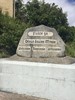
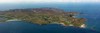
Arranmore, Donegal, Ireland
Agent: Cliff Jacobs - Managing Principal Property Practitioner & CEO - Exquisite Hotel Consultants (Nat.Dpl.Hotel Man (UJ). M.P.R.E.)
Agent Cellphone: +27 (0) 84 413 1071 / +27 (0) 61 716 6951
Agent Office Number: +27 (0) 84 413 1071
Agent Email Address: cliff@exquisitehotelconsultants.com
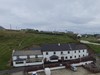
Type: Guest House
Bedrooms: 20
Bathrooms: 20
Showers: 20
Parking: 20
Yield: Not Disclosed
Arranmore Island (Oileán Árainn Mhór) c.1600. ‘Great ridge’
Length: 5.5 miles
Width: 3 miles
Coastline: 17 miles
Distance from the coast: 3 miles (4 km)
Population: 522, rising to over 1000 in summer months
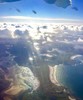
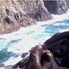
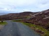
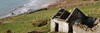
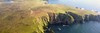
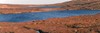
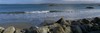
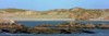
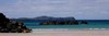
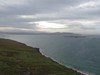
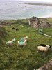
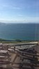
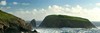
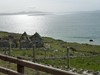
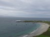
Arranmore Island, Oileán Árainn Mhór, is in the Donegal Gaeltacht (Irish-speaking region), although the inhabitants are mostly bilingual. Arranmore Island is three miles from the Donegal mainland coast and has been inhabited since the early Iron Age (800 BC) - a prehistoric triangular fort can still be seen on the southern side. The western and northern parts are wild and rugged, scenery characteristic of the Rosses area of Donegal with hills, rocks, small lakes and spectacular cliff scenery. There has been a lighthouse on Rinrawros Point since 1798.
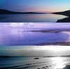
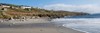
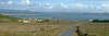
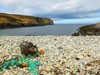
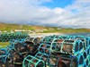
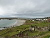
A walking path, the Arranmore Way, circles the island and off the southwestern tip is Green Island, a bird sanctuary for corncrakes, snipes and a variety of seabirds. It is an ideal holiday location for walking, learning Irish, hearing traditional Irish music, diving, bird-watching, cycling, pubs and nightlife and sea and lake angling. The clear waters and numerous marine life make it ideal for snorkeling and SCUBA diving. Two lakes have brown trout and one has Rainbow trout breeding naturally. Boats for sea angling can be hired and there are abundant cod, ling, conger eel, pollock, wrasse, skate, turbot and plaice. There are also many small secluded beaches in addition to the main beaches at Aphort and Leabgarrow.
Arranmore is twinned with Beaver Island, Michigan since October 2000. The initial connection came about when Charlie O'Donnell, his wife and their three young children emigrated to Beaver Island after being evicted from their Arranmore home in 1851, at the height of the Irish famine. The Beaver Island memorial was constructed on Arranmore to commemorate the islands' joint history. The set of statues consist of a beaver (representing Beaver Island) and otter (representing Arranmore Island) and a fish representing the links between the two.
Arranmore Island is steeped in history, myths and legends.
Donegal
County Donegal (/ˌdʌnɪˈɡɔːl, ˌdɒn-/ DUN-ig-AWL, DON-; Irish: Contae Dhún na nGall) is a county of Ireland in the province of Ulster. It is named after the town of Donegal (Dún na nGall, meaning 'fort of the foreigners') in the south of the county. It has also been known as County Tyrconnell (Tír Chonaill, meaning 'Land of Conall'), after the historic territory of the same name, on which it was based. Donegal County Council is the local council and Lifford the county town.
The population was 159,192 at the 2016 census.
Geography and political subdivisions
In terms of size and area, it is the largest county in Ulster and the fourth-largest county in all of Ireland. Uniquely, County Donegal shares a small border with only one other county in the Republic of Ireland – County Leitrim. The vast majority of its land border is shared with three counties of Northern Ireland: County Londonderry, County Tyrone and County Fermanagh. This geographic isolation from the rest of the Republic has led to Donegal people maintaining a distinct cultural identity[9] and has been used to market the county with the slogan "Up here it's different". While Lifford is the county town, Letterkenny is by far the largest town in the county with a population of just under 20,000. Letterkenny and the nearby city of Derry form the main economic axis of the northwest of Ireland. Indeed, what became the City of Derry was officially part of County Donegal up until 1610.
Informal districts
The county may be informally divided into a number of traditional districts. There are two Gaeltacht districts in the west: The Rosses (Irish: Na Rosa), centred on the town of Dungloe (Irish: An Clochán Liath), and Gweedore (Irish: Gaoth Dobhair). Another Gaeltacht district is located in the north-west: Cloughaneely (Irish: Cloich Chionnaola), centred on the town of Falcarragh (Irish: An Fál Carrach). The most northerly part of the island of Ireland is the location for three peninsulas: Inishowen, Fanad and Rosguill. The main population centre of Inishowen, Ireland's largest peninsula, is Buncrana. In the east of the county lies the Finn Valley (centred on Ballybofey) and The Laggan district (not to be confused with the Lagan Valley in the south of County Antrim), which is centred on the town of Raphoe.
History
At various times in its history, it has been known as County Tirconaill, County Tirconnell or County Tyrconnell (Irish: Tír Chonaill). The former was used as its official name during 1922–1927. This is in reference to both the old túath of Tír Chonaill and the earldom that succeeded it.
County Donegal was the home of the once-mighty Clann Dálaigh, whose best-known branch was the Clann Ó Domhnaill, better known in English as the O'Donnell dynasty. Until around 1600, the O'Donnells were one of Ireland's richest and most powerful native Irish ruling families. Within Ulster, only the Uí Néill (known in English as the O'Neill Clan) of modern County Tyrone was more powerful. The O'Donnells were Ulster's second most powerful clan or ruling family from the early 13th century through to the start of the 17th century. For several centuries the O'Donnells ruled Tír Chonaill, a Gaelic kingdom in West Ulster that covered almost all of modern County Donegal. The head of the O'Donnell family had the titles An Ó Domhnaill (meaning The O'Donnell in English) and Rí Thír Chonaill (meaning King of Tír Chonaill in English). Based at Donegal Castle in Dún na nGall (modern Donegal), the O'Donnell Kings of Tír Chonaill were traditionally inaugurated at Doon Rock near Kilmacrennan. O'Donnell royal or chiefly power was finally ended in what was then the newly created County Donegal in September 1607, following the Flight of the Earls from near Rathmullan. The modern County Arms of Donegal (dating from the early 1970s) was influenced by the design of the old O'Donnell royal arms. The County Arms is the official coat of arms of both County Donegal and Donegal County Council.
The modern County Donegal was shired by order of the English Crown in 1585. The English authorities at Dublin Castle formed the new county by amalgamating the old Kingdom of Tír Chonaill with the old Lordship of Inishowen. However, although detachments of the Royal Irish Army were stationed there, the Dublin authorities were unable to establish control over Tír Chonaill and Inishowen until after the Battle of Kinsale in 1602. Full control over the new County Donegall was only achieved after the Flight of the Earls in September 1607. It was the centre of O'Doherty's Rebellion of 1608 with the key Battle of Kilmacrennan taking place there. The county was one of those 'planted' during the Plantation of Ulster from around 1610 onwards. What became the City of Derry was officially part of County Donegal up until 1610.
County Donegal was the worst affected part of Ulster during the Great Famine of the late 1840s in Ireland. Vast swathes of the county were devastated, with many areas becoming permanently depopulated. Vast numbers of County Donegal's people emigrated at this time, chiefly through Foyle Port.
The Partition of Ireland in the early 1920s had a massive direct impact on County Donegal. Partition cut the county off, economically and administratively, from Derry, which had acted for centuries as the county's main port, transport hub and financial centre. Derry, together with west Tyrone, was henceforward in a new, different jurisdiction remaining apart of the United Kingdom, officially called Northern Ireland. Partition also meant that County Donegal was now almost entirely cut off from the rest of the jurisdiction in which it now found itself, the new dominion called the Irish Free State, which in April 1949 officially became the Republic of Ireland. Only a few miles of the county is physically connected by land to the rest of the Republic. The existence of a border cutting Donegal off from her natural hinterlands in Derry City and West Tyrone greatly exacerbated the economic difficulties of the county after partition. The county's economy is particularly susceptible, just like that of Derry City, to the currency fluctuations of the Euro against sterling.
Added to all this, in the late 20th century County Donegal was adversely affected by The Troubles in Northern Ireland. The county suffered several bombings and assassinations. In June 1987, Constable Samuel McClean, a Donegal man who was a serving member of the Royal Ulster Constabulary, was shot dead by the Provisional Irish Republican Army at his family home near Drumkeen. In May 1991, the prominent Sinn Féin politician Councillor Eddie Fullerton was assassinated by the PIRA's opponent, the Ulster Defence Association at his home in Buncrana. This added further to the economic and social difficulties of the county. However, the greater economic and administrative integration with Northern Ireland, following the Good Friday Agreement of April 1998 has been of benefit to the county.
It has been labelled the 'forgotten county' by its own politicians, owing to the perception that it is ignored by the Government of Ireland, even in times of crisis.
About us
Arranmore Island is one of the most westerly points of Europe, steeped in the Irish language, heritage and culture. It is one of the few remaining places where Irish is still spoken as a first language, though as almost all the locals are bilingual, you will have no problem being understood!
It is an ideal holiday location for both sea and lake angling, walking, cycling, snorkelling and diving, exploring the culture and learning Irish, archaeology, wildlife, pubs, music and nightlife. Or just the perfect holiday for those who wish to escape the hustle and bustle of mainland life and who appreciate the beautiful natural scenery on an island of peace and tranquillity.
Enjoy home fires, home cooking, and the famous home welcomes.
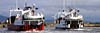
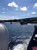
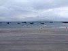
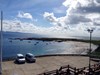
Arranmore Island is approximately three miles off the Irish coast. Travel to and from the island is by local ferry, and all ferries leave the mainland from Burtonport Harbour (journey: 15 minutes approximately).
Accommodation
Ours is a family-run business and you will feel that as soon as you are welcomed at the door.
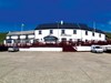
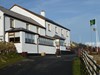
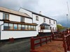
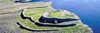
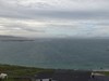
Located on Arranmore Island, one of the most westerly points of Europe off the tip of Ireland's dramatic and historically-steeped West Coast, our Guest House is a superbly appointed newly renovated building overlooking the magnificent beach and bay of Aphort.
We have 20 bedrooms, all en-suite, many of which have superior views over the Atlantic ocean and surrounding islands.
Our staff have already established a reputation of extending real Irish hospitality with their friendly and efficient service.
After a day spent fishing, diving, exploring our magnificent scenery or just relaxing on the beach, come home to experience traditional home-cooking in our Guest Dining Room whilst overlooking the magnificent Bay of Aphort (please mention upon booking if you wish to enjoy your evening meals with us).
Afterwards relax with a pint of the black stuff in our Bar, enjoying a real turf fire, stunning ocean views and many an impromptu traditional Irish music session.
Served by an excellent and frequent car ferry service from Burtonport, the island is only 15 minutes away from the mainland. Car parking is directly outside in our private car park.
Experience a taste of real Ireland in this relaxed, beautiful and homely setting, in one of the few truly Gaeltacht (Irish speaking) areas still in existence.


Cliff Jacobs (Nat Dpl Hotel Man (UJ). MPRE. GA Level 5 TEFL) Managing Principal / CEO Exquisite Hotel Consultants (Pty) Ltd Mobile: +27 (0) 84 413 1071 / +27 (0) 61 716 6951 Email: cliff@exquisitehotelconsultants.com Web: https://www.exquisitehotelconsultants.com © All rights reserved Terms and Conditions apply Scroll down to view our Hospitality Properties and Businesses for sale or lease or lease-to-buy or partnership arrangement or management agreement arrangement.
