


.JPG "Exquisite Properties")


Lydenburg, Mpumalanga, South Africa
Agent: Cliff Jacobs - Managing Principal Property Practitioner & CEO - Exquisite Hotel Consultants (Nat.Dpl.Hotel Man (UJ). M.P.R.E.)
Agent Cellphone: +27 (0) 84 413 1071 / +27 (0) 61 716 6951
Agent Office Number: +27 (0) 84 413 1071
Agent Email Address: cliff@exquisitehotelconsultants.com
Type: Trout Estate
Bedrooms: 33
Bathrooms: 33
Showers: 20
Parking: 50
Yield: Not Disclosed
Lydenburg
Lydenburg is a town in Thaba Chweu Local Municipality, on the Mpumalanga highveld, South Africa. It is situated on the Sterkspruit/Dorps River tributary of the Lepelle River at the summit of the Long Tom Pass. It has a long, rich history, ranging from AD 500 to the present. The name is derived from the Dutch Lijdenburg, or "Town of Suffering", and is named for the experiences of the white settlers. In Northern Sotho, Mashishing means "long green grass." Lydenburg has become the centre of the South African fly-fishing industry and is an agricultural, tourism and mining hub.
History
Ancient history
The area surrounding present day Lydenburg has a long history of human occupation. Rock paintings in surrounding areas point to early Khoe-San hunter-gather groups living on the land.
Lydenburg Heads
Dating back to AD 500, the earliest known forms of African Iron Age sculpture below the equator, known as the Lydenburg heads were found in the area. The seven earthenware sculptures of heads and other pottery from the site are intricately decorated and may have been used for ceremonial or initiation purposes. However, this is speculative as there is little we know today about the people who made these sculptures. Their existence nevertheless points to Lydenburg's remarkable heritage.
Pre-colonial History
From around the 16th century a group referred to as the Bakoni people occupied the area. There is evidence of Bapedi people, who referred to the area as Mashishing, that lived in the surrounding area from as early as the 1700s.
Colonial History
Founding of the town Lydenburg
Lydenburg was founded in 1849 by a group of Voortrekkers under the leadership of Andries Potgieter when they abandoned their previous settlement Ohrigstad (to the north) due to a malaria epidemic. The town became the capital of the Lydenburg Republic ('De Republiek Lydenburg in Zuid Afrika') in 1856 and later in 1857 joined the Republic of Utrecht but in 1860 both these republics joined the Zuid Afrikaanse Republiek (ZAR). The town became the capital of the Lydenburg District of the South African Republic (ZAR).
Lydenburg became important because it was on the wagon route to the port of Delagoa Bay (now Maputo Bay) which was not under British control. In 1871 construction of the road was started by Abraham Espag under the orders of President Thomas François Burgers. The first wagons arrived in Lydenburg from Delagoa Bay in 1874.
Gold Rush
On 6 February 1873, alluvial gold was discovered and within 3 months the Lydenburg goldfields were proclaimed. The First Boer War broke out between Britain and the Transvaal Republic in 1880. A British garrison under Lieutenant Walter Hillyar Colquhoun Long (uncle of the 1st Viscount Long) occupied Lydenburg to control the goldfields. It was from here that the ill-fated 94th Regiment under the command of Lieutenant-Colonel Philip Robert Anstruther marched to Pretoria. The remainder of the garrison at Lydenburg was besieged from 6 January 1881, following Long's refusal to surrender the garrison on 23 December 1880.
Land such as Boomplaats and Aapiesdoorndraai farms, near the town, was purchased by black South Africans in the early 1900s before the 1913 Land Act severely restricted black land ownership in South Africa. The communities here developed and irrigated the initially arid area into valuable and productive farms.
By 1910 the railway reached Lydenburg. In 1927 Lydenburg became a municipality.
Apartheid-Era History
Forced removals from farms surrounding Lydenburg began in the early 1940s and continued through the 1960s. Residents on the farms, especially through the ICU, ANC and local chiefs, resisted the removals in different ways depending on local circumstances and allegiances. Often violently, the apartheid state removed the families to farms further from the town or to Sekhukhuneland. In 2001, in one of South Africa's first completed land restitution claims, Boomplaats farm was bought from Willem Pretorius and returned by the state to the Dinkwanyane community.
Name change
In June 2006, it was announced that Arts and Culture minister, Pallo Jordan, had approved the renaming Lydenburg to Mashishing, meaning "wind blowing through the grass".
Mpumalanga
Mpumalanga (/əmˌpuːməˈlɑːŋɡə/) is a province of South Africa. The name means "East", or literally "The Place Where the Sun Rises" in the Swazi, Xhosa, Ndebele and Zulu languages. Mpumalanga lies in eastern South Africa, bordering Eswatini and Mozambique. It constitutes 6.5% of South Africa's land area. It shares borders with the South African provinces of Limpopo to the north, Gauteng to the west, the Free State to the southwest, and KwaZulu-Natal to the south. The capital is Mbombela. Mpumalanga was formed in 1994, when the area that was the Eastern Transvaal was merged with the former bantustans KaNgwane, KwaNdebele and parts of Lebowa and Gazankulu. Although the contemporary borders of the province were only formed at the end of apartheid, the region and its surroundings has a history that extends back thousands of years. Much of its history, and current significance is as a region of trade.
History
Precolonial Era
Archeological sites in the Mpumalanga region indicate settlement by humans and their ancestors dating back 1.7 million years. Rock paintings, engravings and other archeological evidence throughout the province indicate that Mpumalanga has a long history of human habitation by groups of hunter gathers. Excavations not far from the Mpumalanga border in the Origstad district, show evidence of Middle Stone Age habitation dating back to 40,000 years ago. The Lion Cavern, in Ngwenya on the Eswatini border, shows evidence of people mining iron ore in the Mpumalanga region and surrounding areas from at least 28 000 years ago. Evidence from mine shafts and trade goods shows that there was notable industry in tin, copper, gold, iron, ochre, and bronze. The Lydenburg Heads, from around 500 CE, are Africa's oldest Iron Age artworks south of the equator were found in Mpumalanga. Evidence from a site near Mbombela shows evidence of agricultural societies from between the 6th to 17th century. Bokoni stone-walled sites on the Mpumalanga highveld are indicative of a large precolonial agropastoral society between ~1500 and 1820 CE. These societies became centers of trade, with increasingly large and centralised populations, a pattern that increased as they connected to the Portuguese trading post in Maputo Bay. In this era, groups that would become the Swazi, Pedi, Ndebele, Mapulana and others established themselves in the area that is now Mpumalanga.
Colonial Era
In 1845, as part of the Great Trek, the first Dutch-speaking colonial settlers arrived in what they called the eastern Transvaal. The rest of the 19th century in the region was characterised by colonial encroachment and conflict over land and political control. In 1852, the Boers established the South African Republic. The well established Pedi, Swazi and Zulu kingdoms put up significant resistance against the settlers. The Pedi fought wars with the Boers in 1876 (see Sekhukhune Wars) and the Zulu fought with British settlers in 1879 (see Anglo-Zulu War). These interconnected conflicts played a role in shifting the balance of power in southern Africa to colonial control. After 1860, missionaries, especiailly German missionaries like Alexander Merensky set up mission stations in the region, spreading Christianity and European values. Just as the region had been a center for trade in the precolonial era, in the colonial era, the Eastern Transvaal region became an important thoroughfare for trade between Johannesburg and Delagoa Bay (now Maputo). Gold mining around areas like Pilgrims Rest and Barberton and farming were the main forms of economic activity. On farms in the Transvaal, under a system known as Inboekstelsel, Boers carried out raids to capture children and forced them into indentured labour. During the South African War, the region was the site of notable battles.
Apartheid
When the National Party came to power in 1948, their policy of apartheid intensified the segregation that had defined communities in the Transvaal. Under a policy of forced removals, Black South Africans were evicted from areas reserved for white people and moved into homelands, including KaNgwane, KwaNdebele, Lebowa and Gazankulu. As the apartheid regime implemented oppressive policies that defined almost every aspect of life, activists responded with resistance. In 1959, the small town of Bethal on what is now the Mpumalanga highveld was the center of the anti-apartheid consumer potato boycott in response to the working conditions Black South African labourers faced on farms in the area. The region was influenced by dynamics in exile and elsewhere in the country, for instance Black Consciousness, the Sharpeville Massacre and the 1976 Soweto Uprisings. In the 1980s, under intense repression, youth and labour organizations moblized against the government and townships and Bantustans erupted in political unrest and violence. In 1986, an avoidable disaster killed 177 mine workers in Kinross Mine in the region's highveld. The response to the disaster by the National Union of Mineworkers was a key point in the South African labour struggle. By the late 1980s, the intensity of resistance across South Africa (including areas like Mpumalanga, which hadn't previously been seen as key areas of resistance) combined with economic factors and international pressure was strong enough to end apartheid. On 27 April 1994, when South Africa held its first democratic elections, Mpumalanga province was formed. It was originally called the "Eastern Transvaal" province, but the name was later changed to Mpumalanga on the 24th of August 1995.
Post-apartheid
The liberation movement turned leading party, the African National Congress (ANC) came into power in Mpumalanga after white minority rule ended. A program of land redistribution, aimed at granting land back to the black communities who were forcibly moved during apartheid, had redistributed tens of thousands of hectares to these communities and their descendants. However, the process has been marked by corruption, controversy and has been seen as inadequate to address the extent of apartheid spatial planning. In 2001, 1,270 hectares of the Boomplaats farm near Mashishing was the first farm in South Africa to be expropriated. The post-apartheid era brought significant economic growth to Mpumalanga including notable progress in extending housing and basic services. However, poor governance, corruption and high levels of wealth and income inequality present persistent challenges to the province.
Geography
The Drakensberg escarpment divides Mpumalanga into a westerly half consisting mainly of high-altitude grassland called the Highveld and an eastern half situated in low-altitude subtropical Lowveld/Bushveld, mostly savanna habitat. The southern half of the Kruger National Park is in the latter region. The Drakensberg exceeds heights of 2000 m in most places, with this central region of Mpumalanga being very mountainous. These regions have alpine grasslands and small pockets of Afromontane forest. The Lowveld is relatively flat with interspersed rocky outcrops. The Lebombo Mountains form a low range in the far east, on the border with Mozambique.
Some of the oldest rocks on earth have been found in the Barberton area; these ancient greenstones and metamorphosed granites form the Crocodile River Mountains in the southeast of the province. The Lowveld is underlaid by African Cratonic Basement rocks of ages in excess of 2 billion years. The Highveld is mostly Karoo Sequence sedimentary rock of a younger, Carboniferous to Permian age.
Mpumalanga is the only South African province to border two provinces of Mozambique (Gaza Province to the northeast and Maputo Province to the east), as well as all four regions of Eswatini (Lubombo, Hhohho, Manzini, and Shiselweni Districts).
Climate
The Lowveld is subtropical, due to its latitude and proximity to the warm Indian Ocean. The Highveld is comparatively much cooler and drier, due to its elevation of 1700 m to 2300 m above sea level. The Drakensberg escarpment receives the most precipitation, with all other areas being moderately well-watered by mostly-summer thunderstorms. The Highveld often experiences considerable freezing, while the Lowveld is mostly frost-free. Winter rainfall is rare, except for some drizzle on the escarpment. The differences in climate are demonstrated by comparing the capital, Mbombela, which is in the Lowveld, with Belfast, which is an hour away on the Highveld:
With climate change in the province, rainfall is becoming more variable, temperatures and evaporation rates are rising and extreme weather events are becoming more frequent. It is predicted that these changes will shift biomes so that most of the province will be savanna.
Ecology
Some of the earliest signs of life on Earth have been found in Mpumalanga. In the Makhonjwa mountain range's greenstone belt near Barberton, a fossil layer shows microbial activity that is 3.22 billion years old. This discovery indicates that life emerged on Earth 300 million years earlier than previously thought.
Mpumalanga has a high plant and animal diversity. Many species are endemic to the province.
Owners' factsheet of the property
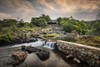
Our property is 651ha, lies within a 15,000ha, Government Gazetted Nature Reserve 15km from Lydenburg and the Spekboom River runs through the middle for a distance of approximately 5km. The property is extremely scenic - one comes over a rise and descends into an unexpectedly beautiful and rugged valley.
There is only one road into the valley and no through roads. Access is controlled by an electric gate and due to the rugged terrain it is more or less impossible for people to enter the valley on foot, therefore it is an extremely safe place to live which is why we do not want to sell the whole property as we intend retiring on one section.
We would however entertain an offer on the whole property should anyone be interested - the section we are not planning sell has 2 guesthouses on it. I can supply details on them if you want them.
Another interesting fact is that the entire valley does not experience load shedding. We have however installed solar at Bag End to reduce running costs.
There are 3 Title Deeds - 342.9, 64.2 and 243.7.
We would like to sell the 64.2 and 243.7 sections and keep the other section for ourselves to retire on. We however do not wish to sell the 64.2 section on its own unless the 243.7 section is already sold.
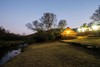
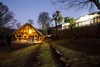
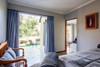
On the section we would like to sell we have the Main House (3 bedrooms) with Granny flat (2 bedrooms), Stone House (6 beds), Bag End (8 beds), Elvinbrook (2 beds) and Bucklebury (4 beds). The last 3 are right on the river bank - the Main House and Stone House also have access to the river.
Our main target market is fly fishermen and we have an excellent reputation of providing outstanding river fishing because we grow out our own trout from fingerlings in dams and ponds which are also on the section we want to sell with which we stock the river regularly. We also have plenty of guests who just want to escape the city for a few days, guests attending weddings on the property next door to us as well as mountain bikers, birders and hikers. We have many foreign tourists who stop over either on their way to or back from Kruger Park which is only 2 hours away.
The following is the detailed information on the section we want to sell.
Main section (243.7ha)
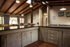
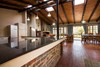
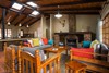
The Main House, Office and Granny Flat form one unit within an established garden with huge wild fig trees with an amazing view over the valley and would make an excellent Conference Venue.
Main house
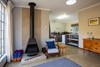
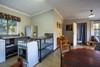
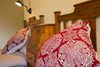
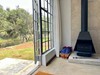
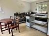
Approx 400sqm thatched house, 3 bedrooms en suite, playroom, large open plan lounge dining room kitchen. Separate scullery. Wood burning fireplace, Slate floors.
Office/trophy room
Approx 100sq with built in gun safe. Furniture and trophies are NOT included.
Granny flat
Approx 100sqm - 2 bedrooms en suite, lounge, kitchen,m sunroom. Wood burning stove, carpet and tiles. Furniture is NOT included.
Closed shed
Approx 100 sqm.
Open shed
Approx 200 sqm.
Separate carport
For the tractor.
Steel feed storeroom
Approximately 25sqm.
Workers' accommodation
5 rooms with flush toilet and donkey hot water systems.
Internet tower
Which we built ourselves and supplies internet to all the buildings.
2 ha of fenced paddocks for horses with feed shelter, water troughs and planted pasture.
2 double game bomas
Mountain top - 1050sqm with water trough.
Near house Bomas 400sq m with 2 water troughs.
Game
Approx 10 Nyala in camp near house.
Baboons, Vervet Monkeys, Kudu, Bushbuck, Bushpig, Warthog, Eland, Klipspinger, Duiker and Leopard roam freely on the Reserve.
Permit approved to keep Sable and we can leave 1 bull and 1 cow
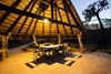
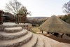
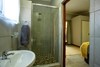
Stone House
Approx 400 sq m, double story, 3 bedrooms, 1 full bath and 1 en suite shower room, open plan lounge kitchen dining room. Large enclosed verandah.
Built in gunsafe. Some furniture may be included.
Store rooms - Stone House
2 X 3m x 3m each, 1 tack room, 1 meat room with sink and slaughter area. Laundry room 3m x 6m with built in cupboards and laundry sink.
Water supply
Pelton wheel and electric submersible pump on river. 20 000lt water tanks.
Hatchery
8 cement dams, 3 earth growing out dams in use and 9 others needing repair. Fenced with diamond mesh to keep out otters.
Bucklebury Cottage
2 bedrooms en suite. lounge dining kitchen area. Wood burning fireplace. On river bank. Approix 150sqm. Furniture is included.
Elvinbrook Cottage
1 bedroom en suite. Open plan lounge, kitchen dining area. Wood burning fireplace. Approx 40sqm. On river bank. Furniture is included.
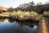
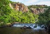
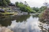
River
Approx 1km river flows through this area with excellent fishing spots and swimming holes.
BAG END (62.4HA) We will only sell this section separately IF the Main House section has already been sold.
____________________________________________________
About us
Situated en-route to the Kruger National Park and centrally located for day visits to great destinations such as Dullstroom, Bourke's Luck Potholes, Sudwala Caves and Pilgrim's Rest.
Scenery and wildlife
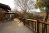
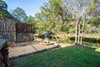
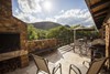
Arriving at our Trout Estate you descend into the spectacular Spekboom River Valley on a winding road flanked by towering rugged cliffs, a magical place reminiscent of Middle Earth from J.R.R. Tolkein's book, Lord of the Rings. Past owners felt strongly about this resemblance and thus the names of the Estate and the cottages will be familiar to fans of the book or the movies.
Our Trout Estate falls within the Mount Anderson Water Catchment Reserve, a Conservancy of many thousands of hectares where kudu, bushbuck, duiker, bushpigs and baboons are prolific and untroubled, wandering the entire area at will and often grazing peacefully while visitors fly fish for trout. Klipspringer are seen almost daily and leopard are seen regularly – occasionally even during the day.
All the above real estate and land can be bought for R 16 million
Our cottages
Except for The Old Stone House, all our cottages are situated on the banks of the perennial Spekboom River. Our river is regularly stocked with rainbow trout, and we have noticed a steady increase in successful spawning activity. The river banks are groomed regularly to provide easy access for fishermen, and guests are encouraged to walk the river and traverse the surrounding roads and trails freely. There is plenty of varied birdlife to interest keen birdwatchers. Hiking routes and Bird Spotting Checklists are supplied in the guest information booklets in each cottage.
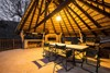
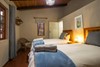
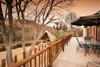
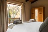
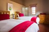
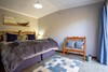
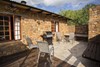
Hobbiton Cottage: Sleeps 8 adults (our flagship cottage)
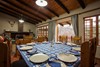
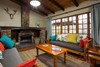
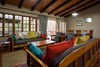
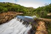
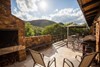
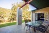
Enjoy your flyfishing trip in supreme comfort. Hobbiton is equipped to a very high standard and features creature comforts such as a Nespresso machine, and percale linen in four ensuite bedrooms, as well as a large open plan lounge/dining/kitchen area for lovely social evenings warmed in the winter by a huge fireplace. Outside is a lovely patio, fully equipped with both wood and gas braai (barbeque) area, overlooking what we call the Hobbiton weir, with the now famous 'Hobbiton Honey Hole' fishing pool right in front of the cottage.
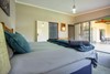
Bag End Cottage: Sleeps 8 adults
Bag End has four bedrooms, as well as a large open plan living space with a large fireplace in the lounge to beat the winter chills. Outdoor entertainment is catered to by an enormous patio (extends the full width of the house) overlooking the river below , as well as a separate thatched braai (barbeque area) a few metres nearer the river. An expansive lawn between the cottage and the river further sets the stage for a quick game of cricket, or touch rugby for those taking the day off from fishing.
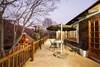
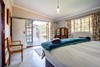
Bucklebury Cottage: Sleeps 4 adults
Commissioned in early 2022 after many years of deliberation, Bucklebury is now welcoming guests with open arms. A quaint little cottage perfectly sized for small families with two ensuite rooms, and a lovely flowing living area with a cozy fireplace. Well equipped for self catering, with a patio - lawn - river setting allowing for maximum enjoyment of the outdoors and fishing (almost) from your verandah!
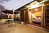
Elvinbrook Cottage: Sleeps 2 adults
Renovated in 2022, Elvinbrook formerly acted as part of the trout packaging plant that was established on the property in the 80's. It has now been transformed into a wonderfully cozy couples retreat, with one ensuite room, and a fully kitted self catering living space, topped off with a fireplace. A perfect space to reconnect and focus.
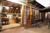
The Old Stone House: Sleeps 6 adults (300m walk from the river)
Situated within the 'Farmstead' on our Trout Estate, Stone House borders on the horse paddocks, and is a mere 300 meter walk to the river if you do want to go fishing. From here you can enjoy the amazing views of the cliffs towering over the old trout hatchery complex, watch Fish Eagles patrolling the valley, or simply sit with your feet up on the verandah, with your favourite drink and enjoy some of the most amazing sunsets around. This is a spacious farmhouse, upgraded in 2022, fully self catering equipped, with three bedrooms and two bathrooms.
Rooms are fully equipped for self catering, and can be configured with either two single beds, or one king bed per your preference.


Cliff Jacobs (Nat Dpl Hotel Man (UJ). MPRE. GA Level 5 TEFL) Managing Principal / CEO Exquisite Hotel Consultants (Pty) Ltd Mobile: +27 (0) 84 413 1071 / +27 (0) 61 716 6951 Email: cliff@exquisitehotelconsultants.com Web: https://www.exquisitehotelconsultants.com © All rights reserved Terms and Conditions apply Scroll down to view our Hospitality Properties and Businesses for sale or lease or lease-to-buy or partnership arrangement or management agreement arrangement.
